Solution provider

Ramboll is a leading international architecture, engineering, and consultancy company, owned by the Ramboll Foundation.
Case
Groundwater management
Water management
Water resource management
+1
Ramboll is a leading international architecture, engineering, and consultancy company, owned by the Ramboll Foundation.
Add the case to your visit request and let us know that you are interested in visiting Denmark
Approximately 40 per cent of the world’s population lives within 100 kilometres of the coast – a trend which shows no signs of slowing. An influx of inhabitants along the coast places pressure on coastal groundwater resources due to increased extraction, where the lower water levels in the aquifer draw saltwater towards the freshwater zones of the aquifer. In a world without human interference, rainfall would replenish groundwater levels naturally, thus preventing saltwater from encroaching coastal aquifers, as an interface between freshwater and saltwater is maintained. However, as the climate becomes more unstable, and cloudbursts become more common, the risk of intrusion is heightened. Furthermore, the growth of cities leads to green spaces being covered by buildings and paved surfaces, which further hinders the natural recharge of aquifers that occurs when it rains.
The intrusion of saltwater in the freshwater aquifers can have considerable environmental and economic impacts, as even very small amounts of saltwater can affect the water’s potability and render the aquifers unusable. A critical step in the management of coastal groundwater resources is mapping and monitoring the distribution of salinity in the subsurface.

The State of California is an example of a region grappling with the risk of saltwater intrusion into its coastal aquifers. Frequent periods of drought, excessive groundwater extraction and legislation requiring transparency around groundwater extraction that first came into force in 2014 means that the water table has often reached dangerously low levels. Furthermore, analysis reveals that the water quality is also declining - in part due to the intrusion of saltwater into coastal aquifers.
In 2014, the State of California passed the Sustainable Groundwater Management Act, which mandated local groundwater authorities throughout the state to manage water resources and reach sustainable use by 2040-2042. Part of the legislation includes a mandate to prevent intrusion of saltwater into the aquifers. However, a lack of available data means there exists a need to measure and precisely understand the extent of intrusion in order to be able to remedy the situation.
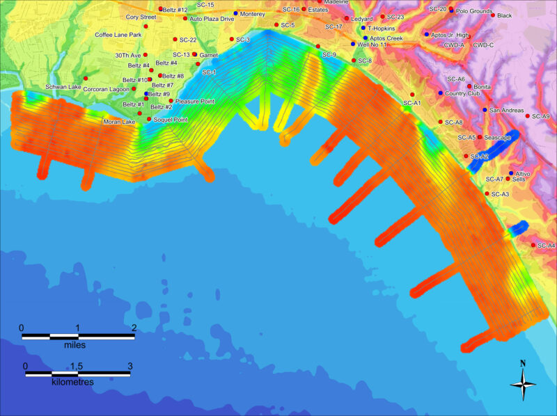
The Monterey Bay region in California has limited surface water resources, and therefore depends on groundwater to meet more than 80 per cent of its freshwater needs. Extensive groundwater extraction has led to significant saltwater intrusion within some of the Bay’s aquifers, and in 2014, the Soquel Creek area of the Monterey Bay region declared a groundwater emergency – in part due to saltwater intrusion. However, a lack of data was available, thus making it difficult to determine the extent of the intrusion. Therefore, together with local authorities, the Danish consultancy Ramboll was tasked with mapping the location of freshwater/saltwater interfaces in the Soquel Creek Area.
Employing a method that had previously been used less than a handful of times in Europe, and the first time the technology had been applied in an offshore setting in the USA, Ramboll conducted geophysical airborne electromagnetic (AEM) surveys to produce 3D subsurface imagery along the coastline in the northern part of the Monterey Bay near Santa Cruz.
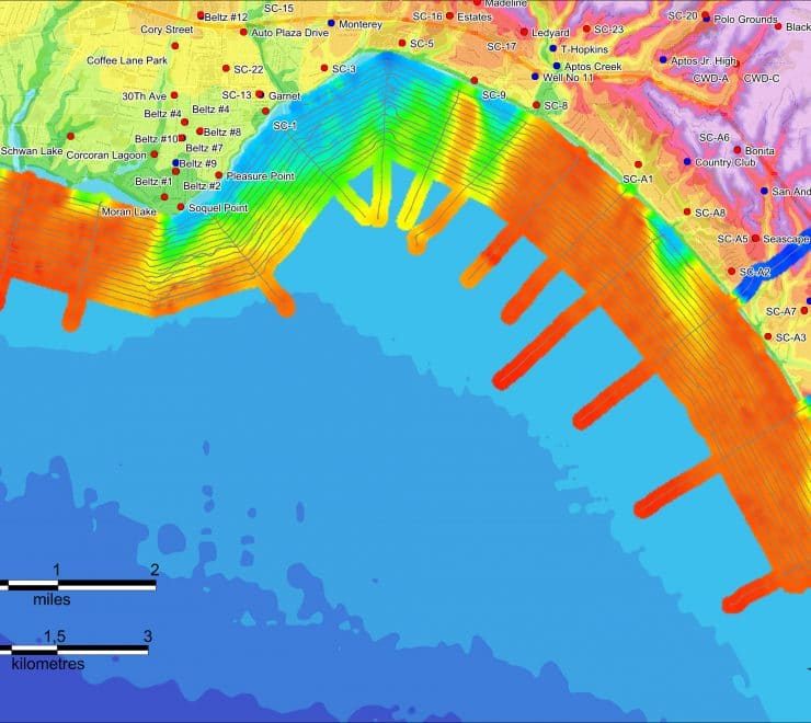
Over the course of a single day, 320 line kilometres of AEM data were acquired off the coast of the Soquel Creek area, spanning an area of 20 kilometres in length, stretching from the beach until 1.5 km offshore. Flown by a helicopter towing the sensor as a sling load, the AEM survey measured variation in the electrical conductivity in the subsurface, i.e., the presence of salinity. The AEM method has the advantage of being able to give extensive spatial coverage relatively rapidly, as well as sample areas difficult or impossible to access with other methods. It is also a more cost-efficient method than installing underwater wells, which is another way to collect data on saltwater intrusion.
Interpreting the data collected by the AEM survey in tandem with other data such as onshore monitoring well water quality data, hydrologic and geologic reports etc., allowed freshwater/saltwater interfaces throughout the Soquel Creek area to be located.
The resulting dataset provides a baseline for assessing changes in the freshwater/saltwater interface and therefore the extent of saltwater intrusion, where it was found to be most prevalent in the deeper aquifers located to the south-eastern part of Soquel Creek. In addition, the data will aid the implementation of the Sustainable Groundwater Management Act and the development of plans to preserve the quality of drinking water for citizens and a sustainable groundwater supply for all.
The Soquel Creek Water district plans to conduct a second repeat survey to see if changes in recharge or extraction rates have changed the location of the saltwater-freshwater interface.