Perspective
Groundwater management
Water management
Water supply
Exploring groundwater as an option
The source of water supplies varies across the world. In some places, surface water is the major source of water, supplied either from natural lakes and rivers or from water stored in dams. In other places, the water supply is based on groundwater. The advantage of using groundwater as a single source or supplementing other water supply sources is that the aquifer is less sensitive to seasonal changes in water consumption and variations in climatic conditions. Aquifers used for abstraction are often thought to be thoroughly protected from pollution, however if pollution does occur, restoration of the aquifer is often a complicated process as damages are long-lasting. Therefore, groundwater has to be managed sustainably. Performing Managed Aquifer Recharge, recharge of surface
water into the aquifer, to obtain a balanced water account is an increasingly common practice and can play a significant role for some countries when considering sustainable groundwater management. Typical considerations include locating optimal sites for water infiltration, understanding where the infiltrated water might flow and if there are any threats to the water quality. By sustainably managing and recharging the aquifer, the otherwise vulnerable surface water is stored in the more protected aquifer ‘savings account’, rendering it reliably withdrawable, when planned as part of overall supply operations or, when prolonged droughts pose a threat to the surface water supply.
Collecting data and generating knowledge is key
The first step towards sustainable groundwater management is to obtain enhanced knowledge and understanding of the aquifer system such as the extent of the aquifer, whether the conditions present in the aquifer naturally protect against pollution or leave the aquifer vulnerable to land activities on the surface. Generally, available knowledge of aquifers is limited and mostly based upon borehole data.
In some countries, borehole information, the only direct, indepth source of information, is treated as private information and therefore not publicly available. In addition, most boreholes are drilled for the purpose of water abstraction and completed at a depth within the aquifer, where it is expected that the desired amount of water can be abstracted. Consequently, information about the underlying and deeper geology is not available and it is impossible to see the full picture. The geological information attained from boreholes can be lacking, as the level of detail in well completion reports vary immensely. Finally, while boreholes provide information at a specific location, they are usually sparse, thus missing crucial information about the extent and continuity of the aquifer units in hydrogeological modelling.
Improving hydrological model
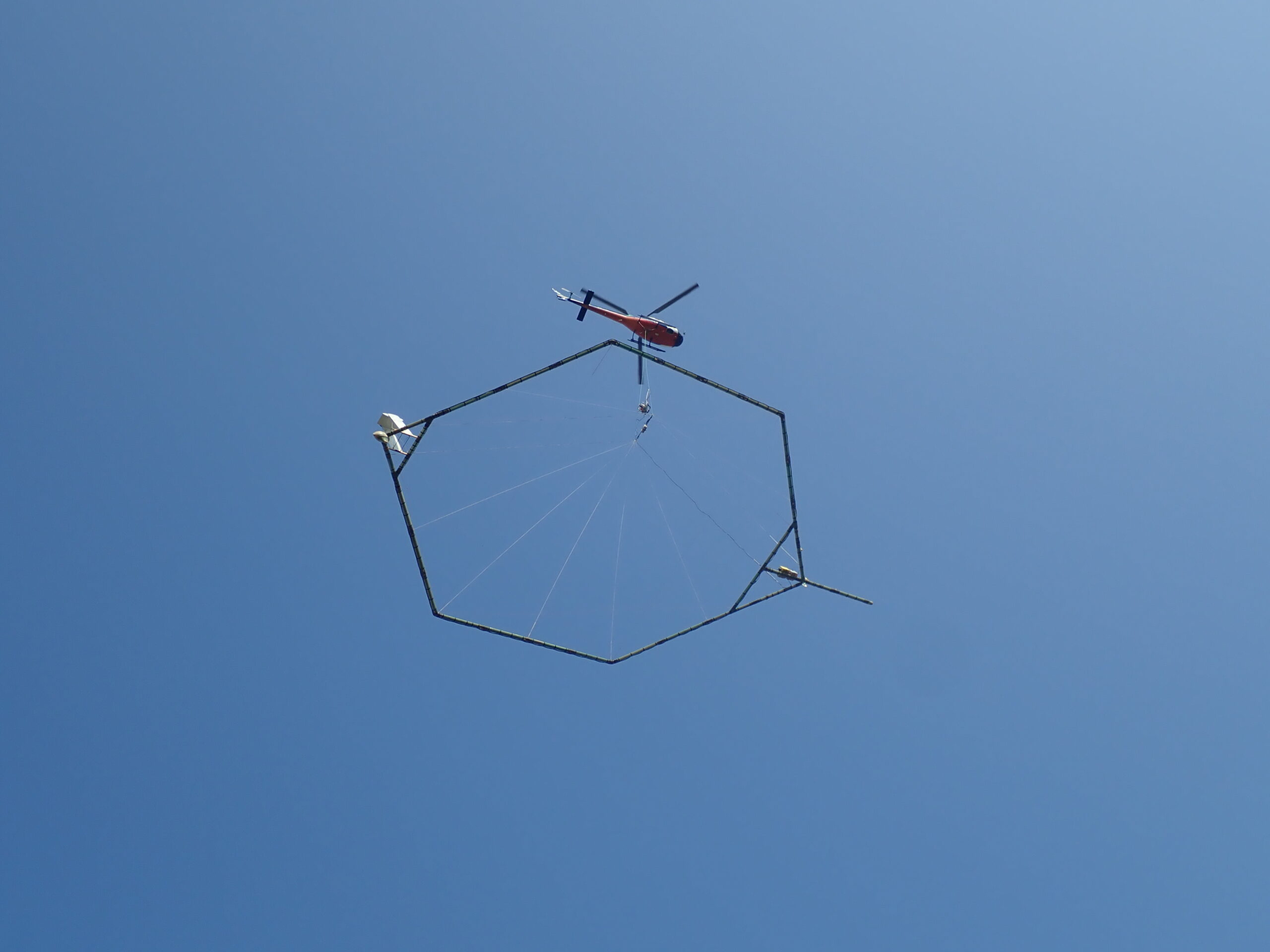
Although the quality of the well completion reports can vary, a great deal of valuable information is hidden in the reports that can help improve our understanding of the aquifer system. The first step towards improved hydrological modelling is quality control and digitisation of existing well data, including lithological and geophysical wireline logs. Conducting geophysical investigations can play a key role in characterising the sedimentology of the aquifers and delineating groundwater infiltration and flow paths. This provides more accurate input to a hydrological model, improves understanding of the spatial distribution of the aquifer’s hydraulic conductivity and supports sustainable groundwater management by allowing decisions to be made based on the most accurate available knowledge.
Combining well completion reports from drilled boreholes with geophysical investigations allow for better modelling and thus, more qualified knowledge. When decisions are to be made regarding sustainable groundwater management, this type of qualified knowledge forms best practice to base those decisions on. Whether it includes adding Managed Aquifer Recharge to the management portfolio, or managing the current groundwater level without this practice, cross-correlation of several datasets will aid in securing qualified decisions on reliable water supply. 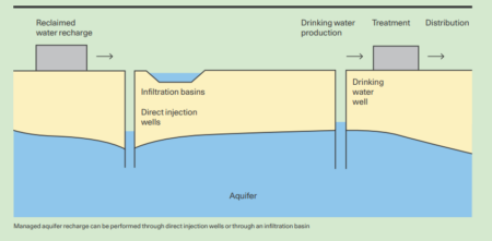
Photo credit: NIRAS
You should consider reading


Partner news
Water management
+1
Hexa-Cover® secure Australia a 73% reduction in water evaporation
20 April 2026


Perspective
Job creation and just transition
+2