Skip to content

Case

Biodiversity

Digitalisation

National method for mapping city nature

22. August 2024

Solution provider

ConTech Lab – a part of Molio

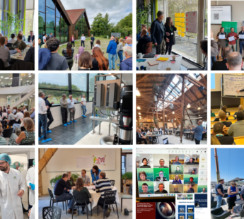
ConTech Lab is the construction industry's shared development platform where companies from the industry can develop and experiment with new ways of using data, digitalization and technology to create the future of construction - a sustainable and efficient one. ConTech Lab commits to sharing all findings and new knowledge to the benefit of the entire industry.

More from ConTech Lab – a part of Molio

Want to see this solution first hand?

Add the case to your visit request and let us know that you are interested in visiting Denmark

Challenge

With urban nature increasingly in the political spotlight, there is a heightened awareness that the impact of business, recreational, and residential areas must be addressed to prevent biodiversity loss and improve urban quality of life. As the largest global consumer of natural resources, the construction sector plays a significant role in this impact.

However, biodiversity remains underdeveloped in reporting frameworks, with companies lacking clear definitions and standards to connect climate change, biodiversity, and their operations. Furthermore, the absence of a unified national approach to measuring and mapping urban biodiversity means cities lack essential information on their current biodiversity status and thus, ability to improve it.

Solution

ConTech Lab has embarked on an ambitious pioneering project in partnership with various industry stakeholders to develop a national method for mapping urban nature.

The goal is to establish a standardized national approach that enhances the understanding and management of urban biodiversity. This initiative aims to empower companies, municipalities, and other stakeholders to effectively nurture and preserve urban nature.

Result

To make the method widely accessible, the process of mapping nature is carried out through an app: bynatur.app. The app is designed to ease fieldwork and automatically digitize data. It facilitates comparison of biodiversity across projects and tracks biodiversity changes over time. Additionally, the app features AI-based standardized measurements that provide quality assessments of individual areas.

The method integrates both quantitative and qualitative AI-based measurements to ensure a comprehensive and interdisciplinary mapping result. Currently, more than 800+ users and 500+ projects are registered in the app.

Products in this solution

National Method for Mapping City Nature

Read more