Case
Climate change adaptation
Coastal protection
Flood prevention
Flood Risk Management, Istanbul
26. March 2013
Want to see this solution first hand?
Add the case to your visit request and let us know that you are interested in visiting Denmark
Istanbul Water and Sewerage Administration (ISKI)/Turkey established under Istanbul Metropolitan Municipality signed a contract with Sweco Turkey to prepare and develop a hydrodynamic model for both Göksu and Yesilçay (Agva) Rivers, with the purpose of mapping the risk of flooding and elaboration of the corresponding mitigation strategies in the Agva Region.
Under the framework of the project, the following results are achieved:
• Flood hydrodynamic model
• Flood hydrodynamic model simulation
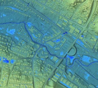
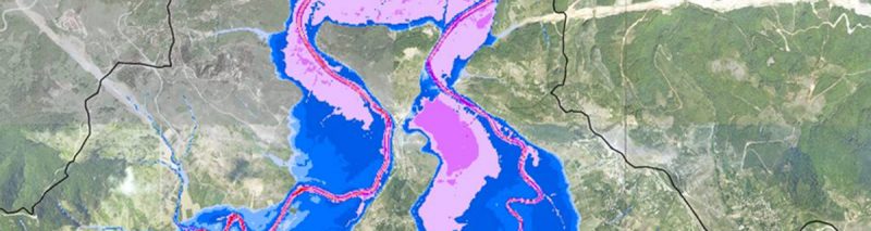
• Flood risk-depth maps
• Flood mitigation projects and project report for Göksu and Yesilçay Rivers
The services provided by Sweco established a flood risk analysis based on the results from the hydrodynamic models for the rivers and flood plain. Moreover, the project identified the most vulnerable areas in terms of flooding, as well as potential mitigation measures to be implemented by the client. The results showed that most of the flooding in Agva is due to high river levels in Goksu, while Yesilcay plays a minor role in the overall flooding of Agva. This is mainly because of the terrain along the rivers and the river flows.
Sweco's services consist of:
- Set up of hydrodynamic Mike 11 model for Goksum and Yesilcay rivers.
- Elaboration of a high-resolution digital elevation model based on photogrammetric maps and survey data. The geometry of the rivers (bottom, side slops, river banks, etc.) was “burned” directly in the elevation model.
- Set up of hydrodynamic Mike 21 model for modelling and routing of runoff.
- Analysis of historical rainfall series. Preparation of rainfall time series based from IDF curves for 25, 100 and 500-year return period.
- Carried out 3-D flood calculation with Mike Flood.
- Flood risk mapping.
- Risk mapping.
- Develop concrete actions to protect the area against flooding.