Solution provider

Case
Groundwater management
Water management
Water resource management

Add the case to your visit request and let us know that you are interested in visiting Denmark
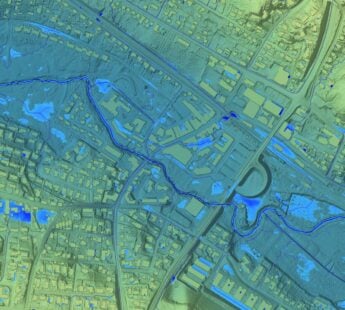
In 2013, SkyTEM304 collected data over 99-square miles of Eastern Nebraska to provide critical information on the condition of aquifers in areas suffering from declining water levels. According to management of the Lower Platte South Natural Resources District (LPS NRD), SkyTEM’s accurate high resolution results provide extensive information about the area’s geology, aquifer characteristics, and water in storage. The NRD’s use of the data is on-going. The data is intended to help landowners in the project area access data showing the depth to aquifer material, the thickness of the aquifer and other basic information.
Once on the LPS NRD site scroll down to Interactive Map (5.5MB) for a full interactive map with aquifer information about individual tracts of land. You will need to have a version of Google Earth installed on your computer. Once the maps open, click any blue-shaded point to see detailed information about the aquifer.